As nature lovers, we spend a lot of time understanding and appreciating the flora and fauna of Minnekhada and area. But, how much time do we spend understanding the stuff that Minnekhada is built on? The stuff that lies beneath?
- Have you ever wondered how the High Knoll was formed?
- What about the marsh?
- Have you ever looked East from the High Knoll and marveled at the table flat “polder” of the Pitt River lowlands?
- Have you ever noticed the “humps” that dot the landscape at Minnekhada and throughout the area?
- What are these things made of and how did they get here?

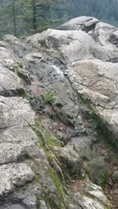
Granitic rock at the top of High Knoll. Look closely and you can see a deeper story here.
My interest in Geology probably started with the stories of the Great Northwest Flood, a massive post-glacial flood that scoured the landscapes of Washington and Oregon at the end of the last ice age. After watching a special on PBS I was hooked and I’ve travelled south of the border several times to see these features for myself, even meeting a couple of the folks who were involved with that research. Interesting to note that new research now indicates that BC likely has experienced our own massive post glacial flood events as well.
On a geological scale however, that’s all just very recent history. Indigenous people were already inhabiting the land around the Pacific Northwest when these events happened. What happened before the glaciers melted and the Cascade Mountain Range broke through the existing rock? Where and how did our prevalent “salt and
pepper” granites form?
Minnekhada is just a very small piece of a much larger geological story throughout time – the story of how British Columbia and other parts of the Pacific Northwest were built. It’s a story of volcanic island chains slamming into the early North American continent, of older and much newer volcanic and tectonic events, of many generations of massive glaciers scouring the landscapes, and of rivers eroding high plateaus and creating land where there once was none. It’s likely that the ground that Minnekhada now sits on experienced all of these processes over the years. There are little clues everywhere, if you look for them.
These processes helped to form the conditions that allowed the present day ecosystems to flourish. They allowed for a slightly drier microclimate on the slopes of the High Knoll. They allowed for a depression where the marsh could form and that in turn provided an almost perfect habitat for amphibians. They provided a steep mountain backdrop that temporarily stalled the winter storms from moving on, allowing for a lush coastal rainforest. They provided extremely fertile and abundant areas that could be utilized by first peoples, and later, by settlers. They created a tidal river, that once was an ocean fjord, but more about that later…
I’d like to explore this story some more at a local level and see how Minnekhada fits into it. I’m looking for like minded people who’d like to come along on this adventure. Stay tuned for future installments in this series and drop me a line if you are a Geologist, or you know one. Or, maybe you are a Geology student looking for a project?
~ STEVE SMITH, January 2025.
~ Photos by Steve Smith.
Steve Smith is the Secretary and Vice Chair of the Minnekhada Park Association and a very active volunteer, who proudly wears the “science nerd” badge. You can contact Steve at secretary@minnekhada.ca


Pingback: What Lies Beneath… Part 2: Strip Away the Trees - Minnekhada Park Association